

GNSS Correction Services Explained: From RTK to PPP-RTK
Global Navigation Satellite Systems (GNSS), including GPS, Galileo, GLONASS, and BeiDou, underpin a rapidly growing ecosystem of applications ranging from precision agriculture and surveying to autonomous systems, robotics, and connected mobility.
While standalone GNSS positioning enables global navigation with metre-level accuracy, many modern applications require significantly higher performance.
Achieving decimetre- or centimetre-level positioning requires the mitigation of multiple error sources that affect GNSS measurements. This is the role of GNSS correction services.
Understanding the capabilities, limitations, and underlying principles of these services is essential for selecting the most appropriate solution for a given application.
Why Are GNSS Corrections Required?
A standalone GNSS receiver determines its position by estimating the distance, or pseudorange, to multiple satellites. The resulting position solution is affected by several error sources, including:
- Satellite clock errors
- Satellite orbit errors
- Ionospheric and tropospheric delays
- Multipath
- Receiver noise
Collectively, these errors limit standard positioning performance to approximately 3–10 metres, depending on receiver quality, environmental conditions, and satellite geometry.
GNSS correction services improve positioning performance by estimating and compensating for these errors using measurements from reference stations with precisely known coordinates.
Depending on the correction methodology employed, positioning accuracy can be improved from metre-level to centimetre-level performance.
How Do GNSS Correction Services Work?
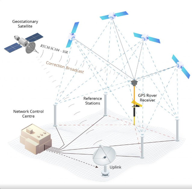
A reference station continuously receives signals from GNSS satellites and calculates the errors affecting those signals.
These corrections are then delivered to a user’s GNSS receiver, commonly referred to as a rover. The rover applies the corrections to improve its position estimate.
Corrections can be delivered through various communication channels, including:
- NTRIP over internet connections
- UHF or VHF radio links
- L-band satellite services
- Direct satellite broadcasts
It is important to distinguish between the correction method and the delivery method. For example, RTK is a positioning technique, while NTRIP is a protocol used to transmit correction data over the internet.
Observation Space Representation (OSR) and State Space Representation (SSR)
GNSS correction services are generally based on one of two approaches.
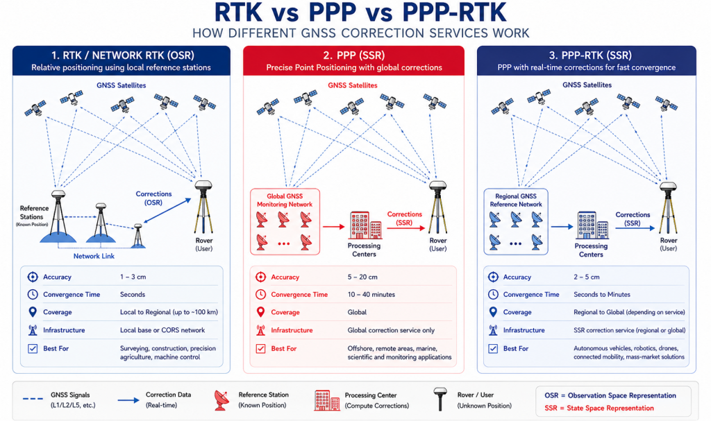
Observation Space Representation (OSR)
OSR corrections are generated for a specific user location and applied directly to GNSS observations.
Traditional RTK and Network RTK services use OSR corrections.
OSR approaches provide rapid ambiguity resolution and excellent positioning performance but require dense reference station networks and generate user-specific correction streams.
State Space Representation (SSR)
SSR corrections model individual error sources, including:
- Satellite orbit errors
- Satellite clock errors
- Signal biases
- Atmospheric delays
SSR corrections are independent of user location, making them more scalable for large numbers of users.
PPP and PPP-RTK services typically use SSR corrections.
Satellite-Based Augmentation Systems (SBAS)
Satellite-Based Augmentation Systems provide wide-area corrections generated from regional reference networks and broadcast through geostationary satellites.
Examples include:
- EGNOS in Europe
- WAAS in North America
- MSAS in Japan
- GAGAN in India
SBAS services primarily compensate for satellite orbit, clock, and ionospheric errors, improving standalone positioning accuracy to approximately 0.5–2 metres.
SBAS also provides integrity information, making it particularly valuable for aviation applications.
Differential GNSS (DGNSS)
Differential GNSS uses code-based corrections generated by a nearby reference station.
Because many GNSS errors are spatially correlated, users operating within a limited distance of the reference station can benefit from significant improvements in positioning accuracy.
DGNSS typically delivers sub-metre performance and remains widely used in marine navigation, GIS mapping, and asset management applications.
Real-Time Kinematic (RTK)
Real-Time Kinematic positioning uses carrier-phase measurements from a local reference station or network of reference stations to achieve centimetre-level accuracy.
RTK performance depends on resolving carrier-phase ambiguities as integer values.
Once ambiguities are fixed, RTK can achieve horizontal accuracies of 1–3 cm and vertical accuracies of 2–5 cm within seconds.
However, RTK performance is constrained by baseline length because atmospheric errors become less correlated as the distance between the rover and the reference station increases.
Single-base RTK is typically limited to baselines of approximately 10–20 km.
Network RTK addresses this limitation by modelling atmospheric errors across a network of Continuously Operating Reference Stations (CORS), enabling high-accuracy positioning over larger regions.
Common Network RTK implementations include:
- Virtual Reference Station (VRS)
- Master Auxiliary Concept (MAC)
- Flächen-Korrektur-Parameter (FKP)
RTK is widely used in:
- Land surveying
- Construction and machine control
- Precision agriculture
- UAV mapping
- Mining operations
Precise Point Positioning (PPP)
Precise Point Positioning achieves high-accuracy positioning without requiring local reference stations.
Instead, PPP relies on precise satellite orbit, clock, and bias information generated from global reference networks.
Unlike RTK, PPP offers global coverage and is particularly well suited to applications operating in remote areas.
Modern multi-frequency PPP solutions can achieve decimetre- to centimetre-level accuracy. However, convergence remains a key limitation.
Depending on receiver capabilities, correction quality, and environmental conditions, convergence times typically range from 10 to 40 minutes.
PPP is commonly used for:
- Offshore and maritime operations
- Remote monitoring
- Scientific applications
- Large-scale infrastructure monitoring
PPP-RTK
PPP-RTK combines the scalability of PPP with the rapid convergence characteristics of RTK.
In addition to precise satellite products, PPP-RTK services provide atmospheric corrections and phase bias information that enable rapid ambiguity resolution.
By reducing convergence times from tens of minutes to seconds or a few minutes, PPP-RTK addresses one of the primary limitations of traditional PPP.
PPP-RTK is increasingly viewed as the enabling technology for high-volume, high-precision applications, including:
- Autonomous vehicles
- Robotics
- Connected mobility
- Uncrewed aerial systems (UAS)
- Mass-market high-precision positioning
Performance Comparison
| Correction Service | Typical Accuracy | Coverage | Convergence Time | Infrastructure Requirement |
|---|---|---|---|---|
| Standalone GNSS | 3–10 m | Global | Immediate | None |
| SBAS | 0.5–2 m | Regional | Immediate | None |
| DGNSS | 0.3–1 m | Local to regional | Seconds | Reference station |
| RTK | 1–3 cm | Local | Seconds | Local base station |
| Network RTK | 1–3 cm | Regional | Seconds | CORS network |
| PPP | 5–20 cm | Global | 10–40 minutes | Global correction service |
| PPP-RTK | 2–5 cm | Regional to global | Seconds to minutes | SSR correction service |
How to Select the Right Correction Service
Selecting the appropriate correction service depends on several factors:
- Required accuracy
- Coverage area
- Convergence time requirements
- Availability of communication infrastructure
- Scalability requirements
- Cost
As a general guideline:
- Navigation applications typically use SBAS.
- Mapping and GIS applications often use DGNSS.
- Surveying, construction, and machine control applications rely on RTK or Network RTK.
- Remote operations without local infrastructure benefit from PPP.
- High-volume autonomous and robotic applications increasingly adopt PPP-RTK.
Challenges and Limitations
Regardless of the correction service employed, positioning performance remains sensitive to environmental conditions.
Key challenges include:
- Multipath and signal obstruction
- Limited sky visibility
- GNSS interference, jamming, and spoofing
- Communication outages
- Poor antenna installation
Even the most advanced correction service cannot compensate for severely degraded signal conditions.
Reliable high-accuracy positioning requires careful consideration of the receiver, antenna, correction service, and communication infrastructure.
Conclusion
GNSS correction services have evolved significantly from traditional differential techniques to globally scalable SSR-based solutions.
RTK remains the benchmark for rapid centimetre-level positioning in localised applications, while PPP enables high-accuracy positioning in areas without supporting infrastructure.
PPP-RTK is emerging as the next-generation architecture for scalable, high-precision positioning, bridging the gap between global coverage and rapid convergence.
As demand grows for autonomous systems, connected mobility, and intelligent infrastructure, understanding the strengths and limitations of each correction approach is becoming increasingly important for engineers, system architects, and technology decision-makers.
Leave a Reply